Evan Jones, University of Bristol (15 March 2024) 7 min read
Bewell’s Cross is a lost monument in Bristol: a boundary marker that stood on the very edge of the medieval county at the top of St Michael’s Hill.1 The ‘Bewel’ (probably meaning ‘Bee Well’) is first mentioned in a late-twelfth-century charter by Count John (later King), defining the limits of the town’s authority.2 The first reference to Bewell’s Cross itself is in 1373, when the border of the newly-established county of Bristol was perambulated and recorded to define the extent of the shire.
By the late fifteenth century, and probably long before, Bewell’s Cross would have had an additional and more prominent association for Bristolians. William Worcester’s topographical survey of the town in 1480 records it as the site of the gallows ‘by hanging and putting to death, for traitors and thieves’.3 Peter Fleming’s analysis of fifteenth-century gaol deliveries, based on records at the National Archives, suggests that in this period around eight people were hanged there each year.4 For the condemned, the Cross offered a final reminder of the possibility of Christian redemption.5
There are published references to Bewell’s Cross as late as the eighteenth century. In 1789 William Barrett noted that Bewell’s Cross was ‘where the criminals now usually pray before their execution at St. Michael’s-hill gallows’.6 Despite this, the exact location of the Cross has long been forgotten, as has its precise position relative to the gallows. In 2020, the Historic Towns Trust for Bristol placed the Cross at the start of what is now Hampton Road, about twenty metres away from the gallows.7
Last year I chanced across a detailed survey of the top of St Michael’s Hill in one of the Plan Books at Bristol Archives.8 This included a depiction of the gallows, as well as one of the ‘shirestones’ that marked the county boundary, situated immediately behind the gallows.
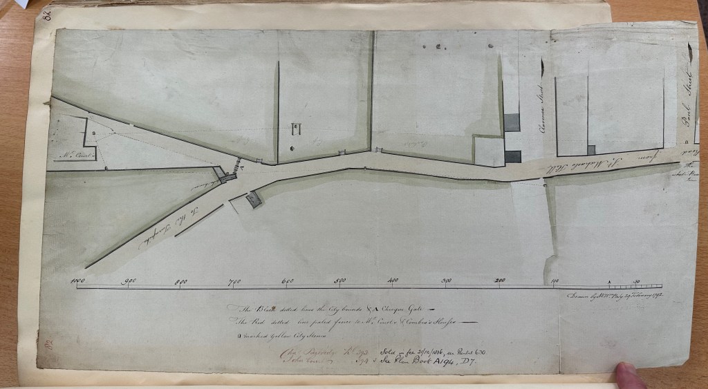
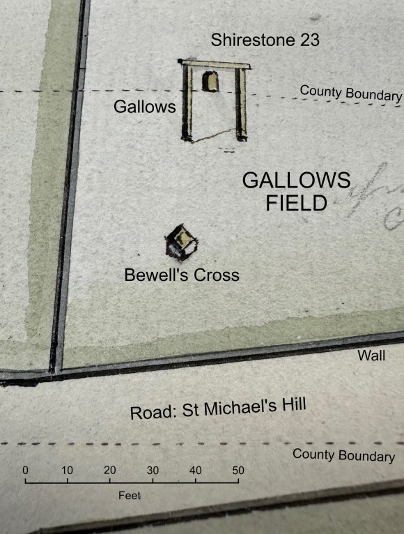
The plan, drawn in perspective, included an object in front of the gallows – a roughly-square three-dimensional object, perhaps 1.2-1.4m across and around 1m high. On the map the object is only a couple of millimetres across and there is no explanation of what it is. So, it was only later that it occurred to me that this might be the base of Bewell’s Cross, minus the cross itself. Such a loss would not have been unusual: many medieval crosses either broke from lack of maintenance or were smashed by post-Reformation iconoclasts who felt all crosses smacked of Papist idolatry. And Bewell’s Cross lay within the siege lines of the Parliamentary forces who attacked Bristol in 1645.
That the object on the 1792 plan was the base of Bewell’s Cross was confirmed by a further visit to Bristol Archives. A later Plan Book includes a detailed 1829 survey of the area, marking out the land that would have to be cleared to lay out a ‘New Road’: what is now Cotham Road.9 This plan, which is on a different orientation, recorded the same oblong object, in the same place, with the same alignment and of the same size as on the 1792 plan.
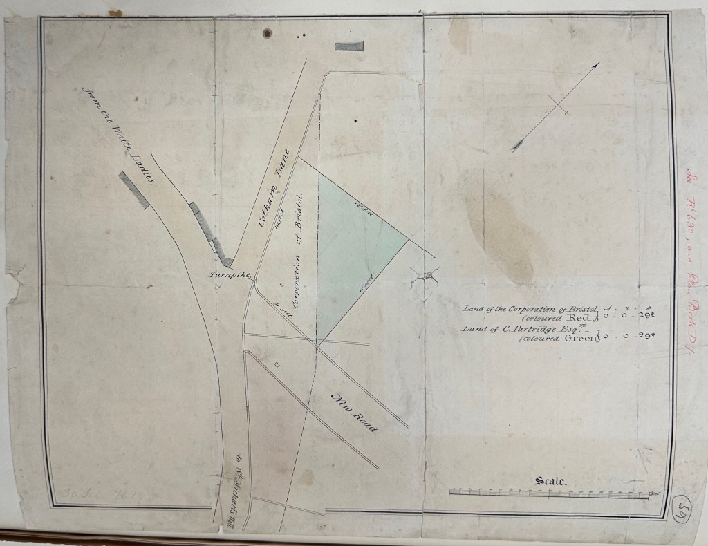
Bristol Archives, Plan Book/C, fo. 59. Copyright: Bristol Archives
In 1820 the city’s gallows were moved from St Michael’s Hill to the roof of the New Gaol down on Cumberland Road. So, the gallows itself is not marked on the 1829 plan. It does clearly show, however, that the object that I thought might be the base of Bewell’s Cross lay in Gallows Field, right in the path of the new road.
The other fruit of my visit to Bristol Archives was the identification of a passage about the Cross quoted by the late nineteenth-century historian and journalist, John Latimer.10 While Latimer’s reference is characteristically oblique, it turned out to come from an obscure manuscript chronicle, written by a mid-nineteenth century Bristol bookseller and antiquarian called Daniel Vickery.11 To be clear, this is not a document that was ever lost or miscatalogued. Before it was transferred to Bristol Archives a few years ago, it had been in the City Library for over a century. It is just that few historians seem to have consulted the chronicle, or even been aware of its existence. For my purposes, what was exciting about Vickery’s chronicle is that it contains his account, apparently based on personal observation, of the destruction of Bewell’s Cross. This is what he has to say:
October 1829
Bewell’s Cross – In laying out the new road now forming forming from the top of St Michael’s Hill through the Gallows Field to Cotham, the fragment of this once venerated memorial of Christianity has been carelessly fractured, rudely thrown from the spot on which it had stood for ages.* When these structures were demolished in the kingdom by order of the government, the pedestal of this Cross was permitted to remain, it having formed one of the boundaries of the city from the earliest period. The date of its erection as well as its early history is obscured in the
midstmist of antiquity. – Fixed by the side of the High Road from Ireland and Wales, it attracted the adoration of travellers & pilgrims on their approach to the city; and standing in the field appropriated to the execution of criminals, it constituted the last object of contemplation, as well as the foundation of the final hope of the expiring malefactor. It marked also the spot consecrated by the blood of the martyrs that our city sent out to offer up their lives in the defence & maintenance of their Faith.12
*afterwards placed in the South Wall of the new Road
While elements of Vickery’s discussion are slightly fanciful, his account of the destruction of Bewell’s Cross seems clear. He confirms that the Cross lay in the path of the new road and that it was dug up by workmen simply because it was in the way. This was not iconoclasm, it was just builders. The stones were then used to construct the new wall bordering the road, presumably because they were available and fit for purpose.13 Vickery’s description confirms that only the base was extant. His notion that the Kingdom’s crosses had been demolished by ‘order of the government’ is mistaken – there never was such an order. However, his belief does imply that the Cross had been broken in the dim and distant past: it was not a recent development. The passage also confirms that Bewell’s Cross was situated directly before the gallows, in such a way that it would, in earlier times, have been the last thing the condemned would see. Since the gallows had only been moved nine-years earlier, this is not something he was likely to have got wrong. Indeed, it is possible that Vickery witnessed executions there. Public executions were extremely popular, often attracting thousands of people. Moreover, Vickery’s chronicle demonstrates his interest in later public executions. It includes sections dealing with both the four men executed for their participation in the 1831 riots and passages about the 1835 hanging of Mary Ann Burdock, whose execution at the New Gaol was said to have attracted at least 50,000 spectators.14
The physical relationship of the Cross, the gallows and the boundary stone confirm and amplify arguments presented about the execution site by Peter Fleming.15 The site chosen for the town gallows was an intensely ‘liminal’ space. Executions commonly took place on jurisdictional borders: London’s Tyburn gallows being a prime example. The condemned were ritually expelled both from their community and the community of the living. However, for the authority of the local assize court to be valid, the execution had to take place within the county. At Bristol the prominent shirestone situated immediately behind the gallows made clear that, while the gallows was on the extreme edge of the county, it was within Bristol. Yet the gallows also lay about seven metres beyond a boundary cross that had long marked the symbolic limits of Bristol. So, those hanged did so in a space that was, in a sense, both inside and outside Bristol. It seems unlikely that this was accidental.
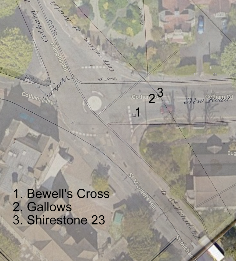
Locating the Cross exactly and identifying its relationship to the gallows through the 1792 and 1829 plans, also allows us to do one more thing. It makes it possible to identify their exact location, to within a metre or two, in the modern city. This is done in this map, which overlays the 1829 plan on an aerial photograph taken from Google Earth.
The results seem disturbingly prosaic. Bewells’ Cross lay on the eastern edge of what is now the mini-roundabout at the top of St Michael’s Hill. The gallows where hundreds, possibly tens of hundreds, of people died, straddled what is today a pedestrian crossing point over Cotham Road. For half a millennium, this was one of the most symbolically charged places in Bristol, a site of public ‘reality theatre’ that must have troubled the dreams of countless Bristolians. But it is now no longer a place, it is just a meaningless space, a few metres above an anonymous crossing point. I find that both fascinating and strangely unsettling.
References
- Richard Coates, ‘Two Bristol Crosses: Bewell’s Cross, St Michael on the Mount Without Parish, and Bewys Cross, Kingsweston’, Transactions of the Bristol & Gloucestershire Archaeological Society 132 (2014), 217–222. The Wikipedia page on Bewell’s Cross, developed and edited by the author, provides a fuller account of the Cross’s history. I would like to thank Bristol Archives for permission to include images of their documents in this story. All images subject to copyright. For their comments on earlier drafts of this piece, I thank Jonathan Barry, Eugene Byrne, Margaret Condon, Richard Coates, Anne Lovejoy, Ben Pohl, Steve Poole, Stuart Prior, John Reeks and Gwen Seabourne. ↩︎
- N. D. Harding (ed.), Bristol Charters, 1155-1373 (Bristol Record Society publications, Vol. I, Bristol, 1930), pp. 8-9; Bristol Archives, CC/1/1. ↩︎
- Frances Neale (ed.), William Worcestre: The Topography of Medieval Bristol (Bristol Record Society Publications, Vol. LI, Bristol, 2000), pp. 86-7 ↩︎
- Peter Fleming, Late Medieval Bristol: Time, Space and Power (Yorkist History Trust, 2024), pp. 302-3. ↩︎
- Peter Fleming, ‘Processing Power: Performance, Politics and Place in Early Tudor Bristol‘ in Compton Reeves, A. (ed.). Personalities and Perspectives of Fifteenth-Century England (Tempe, Arizona: 2012), pp. 150–151. ↩︎
- William Barrett, The History and Antiquities of the City of Bristol (Bristol 1789), p. 665, note ↩︎
- Historic Towns Trust, Bristol in 1489: a Medieval Merchant City (2020). ↩︎
- Bristol Archives, Plan Book/B, 1791 – 1815, fo. 82. ↩︎
- Bristol Archives, Plan Book/C, 1836 – c 1852, fo. 59. ↩︎
- John Latimer, The Annals of Bristol in the Nineteenth Century (Bristol, 1887), p. 134 ↩︎
- Bristol Archives, 45934/18, ‘A Bristol Calendar containing brief notices of such events as have taken place from July 1824 to December 1835, compiled by Daniel Vickery, nd’, p. 159. I thank Margaret Condon for identifying the source. ↩︎
- This is a reference to the protestants burnt at the stake in the 1550s during Mary’s reign: K. G. Powell, The Marian Martyrs and the Reformation in Bristol (Bristol Historical Association pamphlets, no. 31, 1972). Their deaths are memorialised on the wall of Cotham Church: ‘Marian martyrs memorial Cotham Church‘, Wikimedia. ↩︎
- A plaque above one of the stones in the wall claims it to be part of Bewell’s Cross.: ‘Fragment of Bewell’s Cross‘, Wikimedia. ↩︎
- Burdock’s execution on 15 April 1835 was widely reported, it being claimed that ‘The crowd which attended has been computed to amount to no less than 50,000 persons’: Bristol Mercury (18 April 1835) p. 4. . ↩︎
- Fleming, ‘Processing Power’, p. 150-151. ↩︎
